Monday, October 31, 2016

Forget What I Said.... unit "re-armed"

I recently said that I was not inclined to make changes in the order of battle, but.... I have seen a reference to Virginia (US) regiments getting muskets from Massachusetts in two places, including this, from an article on the Battle of Philippi:

"Scott wasn't providing weapons to the pro-Union Virginia troops organizing on Wheeling Island, either. The 1st Virginia Infantry (Union), commanded by Colonel Benjamin Franklin Kelley, had 1,000 men by mid-May. Unionists were forming a second regiment in Wheeling, but until Virginians voted for or against secession, the War Department was maintaining neutrality in the state. McClellan may have sent some old flintlocks, but Virginia's ambiguous status and the federal government's non-interference policy limited what he could do. To arm the men at Wheeling, residents of nearby Wellsburg finally arranged through Governor John Andrew of Massachusetts to purchase some old Springfield muskets"

Since the simulation hasn't started yet, I am going to change the order of battle and "re-arm" the 1st Virginia (US) with Model 1822 Springfield Muskets (converted to percussion). It is very similar to this conversion of a Model 1816 Musket:


Virginians against Virginians

The majority of Jackson's Valley District is composed of Virginia regiments. Lander's Division also includes two (West) Virginia regiments, the First Virginia Cavalry (US) and the First Virginia Infantry (US). It is possible that the 1st Virginia (US) could end up being engaged with the 1st Virginia Battalion (CS) during THE WINTER WAR simulation.

In this photograph of Private Theopolis Richards, Company "A" 1st Virginia (US), it appears that the weapon he is holding is not a M1855 or M1861 rifled musket.  In the order of battle, I had the first US armed with rifled muskets (I can't remember my information source). From this photo, they might have been armed with some form of smoothbore. Or maybe it was a studio prop. Regardless, the order of battle is set and if the 1st Virginia (US) sees action in the simulation, it will be with rifled muskets.

Richards was with the regiment in the period covered by the simulation, and was later captured at Port Republic. He was exchanged and was captured again in 1864.  He wears a forage cap and fatigue blouse (sack coat) and is carrying a side arm tucked into his trousers (perhaps a prop for the photograph).

Sunday, October 30, 2016

Another Step Forward Towards the Simulation Start

This evening each player received a report from his senior staff member. Lander received a report from Captain Simon Barstow, his chief of staff. Jackson received a report from Lieutenant Colonel John Thomas Lewis Preston, Assistant Adjutant General. The reports are dated the night of January 13th and provide the opening positions for all units involved in the simulation. No date has been set for the start of the simulation yet, but it is moving closer.
Preston, before the war.

Barstow, later in the war


Bloomery Gap Map Done

The TC2M Modded map for Bloomery Gap has been posted. It does have some aesthetic around the edges because the differences in elevation from one side to the other are so great. It does work though, in the unlikely event that there is an engagement there during the simulation.


Saturday, October 29, 2016

Bloomery Gap - Also Anisansel's last battle...

Colonel Anisansel is the senior cavalry commander in Lander's Division in January 1862. Historically, to say that Lander was less than satisfied with his performance at Bloomery Gap in February 1862 would be an understatement. The skirmish was  the end of his military career.

I am working on the Bloomery Gap map for THE WINTER WAR simulation. One source I used to help make the map was this map, found on page 241 of Frederick W. Lander: The Great Natural American Soldier, by Gary L. Ecelbarger (Louisiana State University Press, Baton Rouge, 2000). It is an excellent book on Lander, including the period covered in the simulation.


Friday, October 28, 2016

Bloomery Gap - Lander's Last Fight

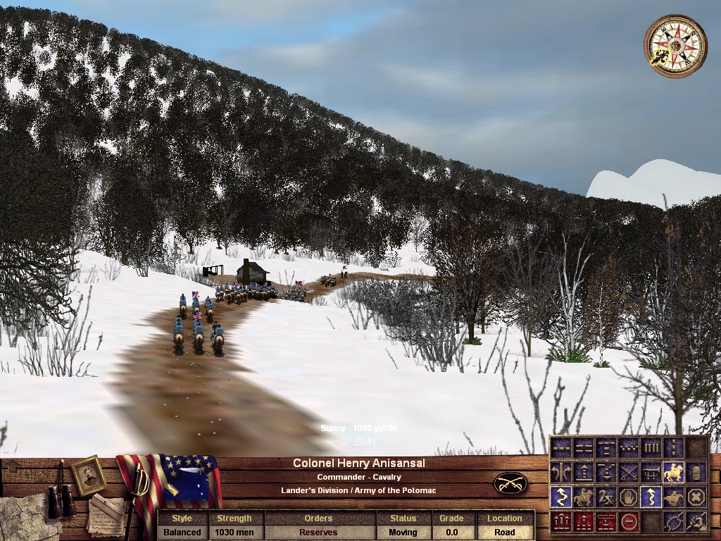
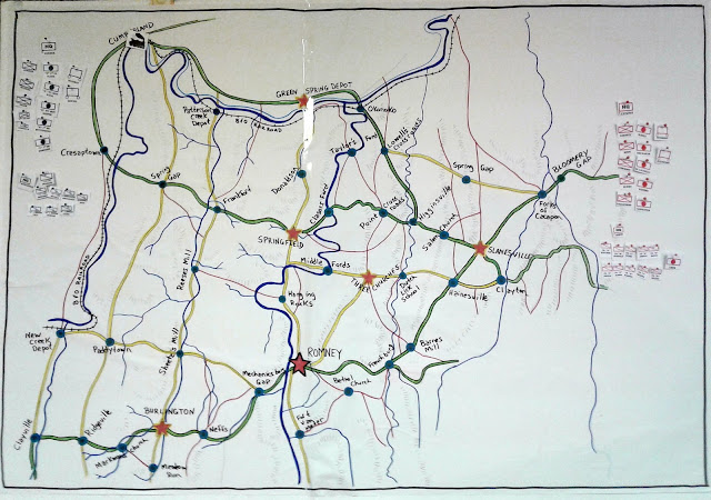
Greg (Lander) has tested all of the maps that had been posted on the TC2M mods page. A few errors have been repaired, so they should all work fine. I am currently working on the Bloomery Gap map. It is the sight of Lander's last fight in February 1862. (He died in the beginning of March.)


Wheeling Intelligencer
February 16, 1862
From Paw Paw. – the First Virginia Regiment of Infantry, and the First Virginia Cavalry, are now in the vicinity of Paw Paw, on the Baltimore and Ohio Railroad, about thirty-five miles east of Cumberland. The boys of the First infantry marched around through the country, after leaving Patterson’s creek, for about ten days without any covering but the canopy of heaven, but fortunately they have all got their tents now and are doing well. Only a few members of the regiment are on the sick list, and its fighting force is as strong as ever it was.
On Sunday last, the day after the rout of the rebels at Bloomery, Gen. Lander sent a small party back to that place to see what the rebels were doing. The rebels had advanced to the vicinity of Bloomery Furnace, and as the reconnoitering party approached they were fired upon from ambush, and Capt. O’Brien, of Gen. Lander’s staff, received a shot in the breast, shattering his shoulder blade, and producing a wound from which he may not recover.
When the news of the taking of Fort Donelson reached Paw Paw, Gen. Lander was intensely delighted. To gratify and encourage his command, he got up on an ambulance and read the dispatch. It is said that there never was such shouting before and never will be again. The troops were all ordered out, notwithstanding the mud, and a regular jubilee was had.


Richmond Daily Dispatch
February 22, 1862
Western Virginia News
--The Superior at Bloomery--The Confederate loss, says the Winchester Virginia, in the attack on Bloomery, Hampshire county, was two wounded and thirty prisoners. The Yankees admit the loss of seven killed and fifteen wounded. The Confederate militia were surprised.--Colonel Scincludiver, of Berkeley, was in command. He escaped. The names of the prisoners taken by the Yankees are as follows:
Col R. F. Baldwin, Capt Lovett, Capt Wm Lodge, Capt Willis, Capt Beard, Lieut Col McCoole; David Carper, Isaac Carper and Chas Duval, of Capt Eddy's company; Chas W Bush, of Capt Bitzer's mounted militia; Jas Bell, of Capt Lodge's company; Thomas Steele, David Gratze, Adam Lawyer, Joseph Knight, Jos Ritter, and Buckner Massey, of Capt Pierce's company; Wm Jenkins, Geo Clark, and Wm Helland, of Capt Willis's company; Samuel McKown, of Capt Lodge's company; Lieut R. L Gray, of Capt Bear's Winchester company; and Jos McCartney, of Winchester.
Our troops, after the engagement, retired to Pughtown, in Frederick county, where they remain ? barring a few, who, with overdone prudence, retired to their homes, and are probably still there.


Official Records of the War of the Rebellion
Series 1, Volume 5, p. 405-407 Report of Brig. Gen. Frederick W. Lander, U. S. Army, of affair at Bloomery Gap, West Virginia.
PAW PAW, February 14, 1862?8 p. m.
The railroad was opened to Hancock this morning. Telegraph the same. Had an important forced reconnaissance last night completed to-day. Broke up the rebel nest at Bloomery Gap. Ran down and caught 17 commissioned officers, among them colonels, lieutenant-colonels, captains, &c. Will forward a descriptive list. Engaged them with 400 cavalry. Infantry not near enough to support, and enemy retiring. In all, 65 prisoners; killed 13. Lost 2 men and 6 horses at their first fire. Led the charge in person. It was a complete surprise. Colonel Carroll, commanding Fifth or Eighth Ohio, made a very daring and successful reconnaissance immediately afterwards to Unger's Store.
Major Frothingham is entitled to credit for building, under my direction, in 4 hours, in the dead of night, a complete bridge of wagons across the Great Cacapon, at an unfrequented road. Two columns of 2,000 men each marched 32, one column 43, miles since 4 p. m. yesterday, besides bridging the river. Papers taken and my own reconnaissance south prove the country clear and Jackson and Loring in Winchester. Made the move and occupied Bloomery Gap and Point?s Mill east on belief by deserters that General Carson?s brigade was there.

General Dunning has just arrived at New Creek from Moorefield, 40 miles south of Romney. Captured 225 beef cattle and broke up the guerrilla haunt there. Two of his men badly wounded. Killed several of the rebels.

As the work intrusted to me may be regarded done and the enemy out of this department, I most earnestly request to be relieved. If not relieved, must resign. My health is too much broken to do any severe work.

F. W. LANDER,
Brigadier-General.

Major-General McCLELLAN.
NOTE. General Williams can move over the river without risk. I respectfully commend Colonel Carroll to your notice. He is a most efficient and gallant officer. Lieut. H. G. Armstrong, acting assistant adjutant-general, and Fitz-James O'Brien joined me in a charge by which rebel officers were captured and confidence restored after cavalry had been checked.


Report of Col. J. Sencendiver, Virginia Militia, of affair at Bloomery Gap, West Virginia.
HDQRs. SIXTEENTH BRIGADE, VIRGINIA MILITIA,
Pughtown, February 17, 1862.

SIR: I have the honor to submit the following report of the engagement into which we were surprised on the morning of the 14th instant:

Our advanced pickets caine in about daylight and reported the enemy advancing upon us in large force. I gave orders to have the baggage packed immediately and the men prepared to meet the enemy and repulse him if possible. The Thirty-first Regiment, Colonel Baldwin, being quartered nearer the point from where the enemy was advancing than the balance of the command, rushed hurriedly to meet him. The Fifty-first, Major Wotring, and a portion of the Eighty-ninth, commanded by Major Davidson, hastened to his aid, but before they reached him the enemy's cavalry dashed through his ranks and inclosed him between them and their infantry and captured himself and nearly all his command. Majors Wotring and Davidson then took position on [a] hillside near the road and commenced a brisk fire on the cavalry, who advanced about 400 strong in full speed in pursuit of our wagons. While they were engaged with cavalry the infantry flanked them on the right and captured a number of their men and officers. As the cavalry neared our teams they were met by the Sixty-seventh Regiment and Company A, of the Eighty-ninth Regiment, who took a position on the hillside near the road and poured a heavy volley into them and checked them for a short time, but they again dashed forward, overtook our wagons, captured several of them, and turned them back towards Bloomery. At this juncture the Sixty-seventh and Company A, Eighty-ninth Regiment, advanced rapidly on either side of the road and commenced a brisk fire on them, and finally drove them back and recaptured the wagons. This was effected without the loss of a man. The enemy lost several men and horses killed at this point.

We then continued on after our wagons. The enemy followed us from this point about 2 miles, but at respectful distance. He picked up 1 or 2 stragglers and then retired.
We reached this place at sundown, and, as before reported, I sent yesterday morning a party with a flag of truce to bring off our dead and wounded. After a diligent search they did not find any killed and but two wounded, neither of them mortally.

They learned that the enemy was from 7,000 to 10,000 strong, commanded by General Lander. He returned the same evening towards Paw Paw, but threatened to return in two days. His loss was 11 killed and several wounded.

Our loss, I regret to say, is over 50 officers and privates missing.

Annexed is a list of officers captured: Col. B. F. Baldwin, Thirty-first Regiment; Capts. William Baird, acting assistant adjutant-general, and G. M. Stewart, Eighty-ninth Regiment; Capts. Thomas McIntyre, William Lodge, and Byron Lovett, Thirty-first Regiment; Capt. James Willis, Fifty-first Regiment; Lieut. Charles H. Brown, Thirty-first Regiment; First Lieut. William Wilson, Eighty-ninth Regiment; Lieuts. William A. Holland, Thomas Steele, R. L. Gray, A. L. White, H. R. Hottel, Isaac Rewner, and Joseph Seibert, Fifty-first Regiment.

All the officers and men engaged behaved themselves with commendable bravery, and I think they deserve great credit for having saved our stores and baggage.

Very respectfully reported.
J. SENCENDIVER,
Colonel, Commanding Brigade.
Major-General JACKSON.


Thursday, October 27, 2016

Simulation Premise


Romney and the South Branch Valley

Federals under George B. McClellan and William S. Rosecrans launched a successful campaign in western Virginia in the summer and fall of 1861, with victories at Philippi, Rich Mountain, Carnifax Ferry, and Cheat Mountain.  As the winter of 1861-1862 set in, both sides ascribed importance to the Romney, the seat of Hampshire County Virginia, and the surrounding area. Strategic considerations included:

1. Food and Forage around the South Branch Valley for the winter

2. A stepping off point for the attack or defense of the B&O Railroad from New Creek Depot to Green Spring Depot.

3. Establishing a presence to protect and promote loyal interests

Confederate and Federal forces established the occupation of Romney as a priority.


Bath-Romney Campaign: Historical Premise

Major Thomas J. Jackson, commander of the Confederate Valley District, was not opposed to fighting in the winter. In December 1861, he led an expedition to attempt to destroy dams that were critical to the operation of the Chesapeake and Ohio Canal. Re-enforced by Brigadier William W. Loring's Army of the Northwest, Jackson left Winchester and set off on a winter expedition on New Year's Day 1862. On January 4th, Jackson captured the town of Bath after a short skirmish and then  moved on Hancock, Maryland.
 
As Jackson was moving on Bath, Brigadier General Frederick W. Lander was on his way to take command of a new division of the Army of the Potomac. It was being carved out of William Rosecrans' Department of West Virginia, with additional new units from Ohio and Pennsylvania. Lander arrived at Hancock around the same time that Jackson appeared on the opposite bank of the Potomac, demanding that the Federals surrender the town. Lander refused. Jackson shelled the town to little effect and then turned his men around on January 7th and started moving on Romney.
 
Lander correctly guessed Jackson's intentions. He had his men at Hancock withdraw to Cumberland, leaving Hancock to elements of Williams' Brigade, Banks Division. Lander then rushed to Romney, where several units of his new command were occupying the town. Knowing he would be outnumbered by Jackson, Lander ordered the evacuation  of Romney and withdrew towards Patterson Creek.  By January 14th, Jackson was headquartered at Bloomery Gap and preparing to move his Valley District into Romney and contemplating a move against Cumberland. This is when THE WINTER WAR simulation begins.
 
Non-Historical Elements
THE WINTER WAR command simulation is loosely based on the second half of the Bath-Romney Campaign, but provides a "what if" scenario. Certain non-historical elements have been added or changed to enhance the game experience, make the simulation more practical to run, and more fair and interesting for the players. These include:
 
  1. Absence of Loring: Brigadier William W. Loring is not present in the simulation. Army of the Northwest units report directly to Jackson. Historically, Loring was present and there was considerable friction between he and Jackson, culminating in the "Loring-Jackson Incident."
  2. South Branch Bridge Out: The B&O Railroad bridge over the South Branch of the Potomac is out between Green Spring Depot and Okonoko. Historically, this bridge was destroyed in the summer of 1861, but repaired by the end of November. In THE WINTER WAR, the B&O stops at Green Spring Depot.
  3. Federal Troop Arrivals and Organization: In THE WINTER WAR, new units have arrived from Ohio and Lander's Division is fully organized as of January 14th. Historically, this did not happen until one week later.
  4. Frenchburg: Historically, the town of Frenchburg had been burned by Colonel Samuel H. Dunning while returning to Romney after his command defeated Confederate militia at Hanging Rocks (Blue's Gap) on January 7th. In the simulation, Frenchburg appears as a larger town than what is was originally and is not burned.
  5. Unit Strength: Sickness had depleted much of Jackson's force between when it left Winchester and when it finally arrived in Romney.  Unit strengths in THE WINTER WAR are greater than what they would have been historically.
Scored Campaign
THE WINTER WAR is a scored campaign simulation based on the objective of successfully occupying Hampshire County Virginia in January 1862.
 

Wednesday, October 26, 2016

Old School Component

Once the simulation gets started, I will be tracking calculating movement on spreadsheets and paper until the time that two opposing units meet each other and I issue contact reports. To supplement the paper, I also will be plotting movement with markers, map pins, and a large (4 ft) map of the campaign theatre.


Tuesday, October 25, 2016

Cavalry in THE WINTER WAR Simulation

Cavalry in THE WINTER WAR simulation could be banded together as a fighting force, but that is probably not the best use. With a lot of ground to cover, cavalry would do excellent service in locating the enemy, disrupting enemy attempts to forage, destroying railroad, or holding objectives until infantry arrives. The cavalry is set up to do this in the orders of battle.

Lander's Division has several cavalry companies that can be used for independent service, or banded together to make a stronger force:
  • The Washington Cavalry, Capt. Greenfield
  • The Ringgold Cavalry, Capt. Keys
  • Co. A, 1st Ohio Volunteer Cavalry, Capt. Robinson
  • Co. C, 1st Ohio Volunteer Cavalry, Capt. Menkin
  • Co. A, 1st Maryland Potomac Home Brigade Cavalry, Capt. Cole
  • Co. B, 1st Maryland Potomac Home Brigade Cavalry, Capt. Horner
  • Co. D, 1st Maryland Potomac Home Brigade Cavalry, Capt. Curil
The size of each company ranges between 75 and 90 men. The 1st (West) Virginia Cavalry also has a battalion of 5 companies present (450 men) under Lieut. Col. Richmond.

Lieut. Col. Turner Ashby's cavalry is attached to the Valley District with three pieces of horse artillery under Capt. Chew.  In the order of battle, Ashby's companies are organized separately:

  • Co. A, Capt. Hatcher
  • Co. B., Capt. Winfield
  • Co. C., Capt. Myers
  • Co. D, Capt. Jordan
  • Co. E., Capt. Bowen
  • Co. F., Capt. Sheetz
  • Co. G, Capt. Mason
  • Co. H, Capt. Harper
  • Co. I, Capt. Shands
  • Co. K, Capt. Miller
In total, Ashby starts out with 639 men plus his horse artillery. But... they may be spread out across the campaign theatre. The Confederate player may choose to consolidate them as a more effective fighting force, or keep them as individual companies or groups of two or more companies.

Cavalry is likely to meet enemy cavalry. How will each side use its horsemen to best advantage to achieve control of Hampshire County and a strategic victory?


Monday, October 24, 2016

Simulation Strategy: Base of Supply Challenge

In a previous post, I noted the Federal advantage of having access to the B&O Railroad and a Confederate advantage is the rail lines are cut. Another strategic consideration is keeping a clear line of supply. Romney is the primary objective of the campaign with the most points awarded for control. It is in the south central part of the campaign theatre. The opposing bases of supply (Cumberland and Bloomery Gap) are in the northern corners of the theatre, connected by turnpikes and with a short-cut available that is a secondary road. Federals have rail access to Green Spring Depot, about half way to Bloomery Gap.

What will the Confederates do? How much resources will be used defending the supply line to Bloomery Gap and how much will be allocated to taking Romney and other objectives. Likewise, how many resources will the Federals allocated to guarding the railroad and preventing an enemy move against Cumberland?  Green Spring Depot, Okonoko and Lowell's Cross Roads could become a hot spots. Or may a move through Taylors Ford.... 

This is the difference between a campaign simulation and a tactical simulation. During a campaign, there are so many considerations that it becomes almost impossible to have all of your army together at the same place. 

Shaking out the Bugs

Greg (Lander in the upcoming WINTER WAR command simulation) has the BOW mod working and is testing maps. A few fixes have been made so far. None of them were game crashers, but every little fix helps in performance.

Greg also has a unit mod up and working for the order of battle, including great coats and flags.  I will post this soon, which will also use of the official TWW order of battle as I have it set at the start of the simulation.

TC2M Re-Release

Take Command 2nd Manassas is being re-released on Steam. It is the same game, but with all of the patches in place so it can be operated in Windows 10 without additional patching. It's great to hear that this classic game is not forgotten.

TC2M Re-Release on Steam

Sunday, October 23, 2016

Saturday, October 22, 2016

Cumberland - Still in Progress

The Cumberland map is still in progress. I could have made it a little more accurate in terms of representing specific buildings, but at this point I just want to get these final maps done, at least to a a working draft level before the start of the simulation.

This screenshot shows progress so far. It is taken from the area around Washington Street, looking east.

Friday, October 21, 2016

Still working on Cumberland Map

Cumberland has a lot of buildings. Even just a working draft is going to take a while. I have about a quarter of the buildings in so far.

Thursday, October 20, 2016

The Railroad and Campaign Strategy

The Federals (Lander's Division) starts THE WINTER WAR command simulation with the Baltimore and Ohio Railroad under their firm control from New Creek Depot to Green Spring Depot. This gives the Federals several advantages.  1) They can quickly move troops from the north border of the campaign theatre to the western border.  2) They can move supplies to the various supply depots along the railroad, and 3) Their ammunition is resupplied by rail as long at it is open out the western side of the campaign theatre at New Creek Depot.

If the railroad is cut, however, Federal commissary supplies will be at diminished capacity. Confederates will restock commissary supplies faster and deliver more commissary supplies with their commissary trains (wagons).

So how important will the railroad be in the players' campaign strategy? How much effort will the Federals put into defending the railroad, and how much is it worth to the Confederates to cut the rail connections?  Allocating resources to defend or attack the railroad will have an influence on how many resources can be allocated to take and hold objectives in other parts of the campaign theatre. Difficult strategic choices are ahead....

Tuesday, October 18, 2016

Shenandoah 1862

Shenandoah 1862 y Peter Cozzens is an excellent book on Jackson's Valley Campaign. While most of us are familiar with Jackson's activities in the Valley during the spring, Cozzen also covers the winter of 1861-1862. The first 135 pages offer a lot of excellent background, including chapters that offer insight into the period of units covered by THE WINTER WAR  command simulation. This is a great read for anyone wanting to learn more about Jackson facing off against Lander in January 1862 (as well as the rest of the campaigning in the Valley).

Goodbye Green Flag

When I set up the order of battle file I will use when running TC2M during the simulation, I used a green flag for the 33rd Virginia, a regiment in Garnett's (Stonewall) Brigade. The "sprite" for the file is very nicely done, with the flag labelled as the "Emerald Guards."  The Emerald Guards, however, were only one company in the regiments. I doubt that it was being used as a regimental flag.

I briefly shifted the green flag to the 1st Virginia Battalion (Irish Battalion), which was an Irish unit. I couldn't find any evidence, however, that the 1st VA Battalion ever carried a green flag. So.... I took it out. There will be no green flags in the order of battle file used in the simulation.


A great flag that was well represented as a TC2M sprite, but it will not appear in THE WINTER WAR simulation.

Monday, October 17, 2016

Cumberland Map Started

I started on the working draft for the Cumberland TC2M modded map. I wanted to start with Bloomery Gap, but realized there were some challenges with that map. Bloomery should have been simpler, because there is no river or rails, but lining up the steep slopes of the mountains for a smooth transition at the map edges is going to be difficult. I might just leave it with flat sides around the edges (kind of like a map in a box). I doubt there will be much, if any, action all the way in the rear of the lines anyway, but you never know.

Cumberland also has some inherent challenges: a river, canal, mountain, and curving railroad through an urban setting with lots of buildings. I will see how it will go. Like Bloomery Gap, I don't think it is likely to see a large action there, but it is possible.

Sunday, October 16, 2016

Cresaptown Working Map Posted

This weekend I managed to post two working draft TC2M maps: New Creek Depot and Cresaptown. The maps work and can be used by players to view topography and terrain, as well as skirmishes. They need a few more details before the could be considered finished, but they are playable, there will be no major changes to the overall topography, terrain, and households.

Cresap, not Crespa

I have been consistently using a misspelled town name. The town to the south of Cumberland should be Cresaptown, MD, not Crespatown.  I will go back and revise all of the maps affected by this over the next week.

Final Orders of Battle Posted

I have updated the Federal order of battle to reflect changes made to Robinson's Battery. The final orders of battle are posted on the Player Resources Page. The Final Confederate Order of Battle (OOB) is dated 10.11.2016 and the final Federal OOB is dated 10.16.2016. These are what will be the opening orders of battle for the simulation.

Saturday, October 15, 2016

New Creek Depot Map at Working Draft Level Done

The New Creek Depot TC2M map is done at working draft level and posted. It doesn't have any railroad tracks laid and there are no barns or outhouses, but the main buildings are there and the North Branch of the Potomac has been set in. More details will be added if there is a battle on the map (or when I have time). Next map....   I haven't decided yet.  Maybe Crespatown.

Friday, October 14, 2016

OOB Change - Union Artillery

I had Robinson's Battery (Battery L, 1st Ohio Light Artillery) armed with four 12lb howitzers and two 6lb guns. It should have been four 6lb guns and two 12lb howitzers. This has been corrected.

I am still debating whether or not to change Huntington's Battery (Battery H, 1st Ohio Light Artillery). Some sources have its original armament as six bronze smoothbore guns. Another source has it as six 13lb James guns. Currently, I have it set as six 12lb howitzers, but I am debating whether to change it to James (rifles) as it appears in the official records with Shields' Division in March 1862.

New Creek Depot Photograph - 1865

This historic photo of New Creek Depot in 1865 is interesting for several reasons. The photo is taken from near the North Branch of the Potomac from the approximate location of house listed as T. B. Davis in the New Creek Depot locality map used for the simulation. The image is looking south and the flat nature of the plain where the camp is located is evident. The railroad is visible with a train behind the camp.

On the hill in the background is one of the forts that was built during the war to protect the camp and the B&O Railroad. It was not present at the period covered by the simulation.

The camp belongs to the 22nd Pennsylvania Cavalry. The Ringgold Cavalry and Washington Cavalry appear as independent companies in the simulation. They later were joined as a battalion and then incorporated as companies A and B of the 22nd.


New Creek Depot and other maps - Draft Form

I have started using a USGS topographic map to start drawing out the topographic for the New Creek Depot TC2M modded map. The start of the simulation is starting to draw closer, so I have decided to work on all of the final maps, leaving them in draft form.  I will set the topography, paint on the ground terrain and maybe put in some of the main buildings. I won't lay down the railroads or "dig out" the river on the New Creek Depot, Crespatown, Cumberland, and Fort Van Meter maps. I can then post them as "drafts."

Maps still in draft status will allow players to view the terrain if they are considering advancing onto one of those maps. Skirmishes could be fought on drafts and it would only take a couple of evenings to take a map from draft to final status if there is a battle.

So.... next map up: New Creek Depot (draft status).

Wednesday, October 12, 2016

OOB Change - Rank Correction

Before posting the revised Confederate order of battle, I made a correction. Samuel Read Anderson's rank was corrected from Colonel to Brigadier General, the rank he held at the time. Anderson commanders the Tennessee Brigade (1st, 7th and 14th) that is attached to Jackson from the Army of the Northwest.

Tuesday, October 11, 2016

More Confederate OOB changes - Artillery

I am making some additional changes to the Confederate Order of Battle for the simulation. Lieutenant Cutshaw's section appears in the orders of battle, although it had historically been captured in the week before the period covered by the simulation. The section was two small guns manned by members of the 33rd Virginia. I had thought of removing it from order of battle for a while and have decided pull it. The guns were four pounders and I will not enter them into the Federal OOB.

But.... I have also realized that the Rockbridge Artillery (Capt. McLaughlin) was not accurately represented in the order of battle. I had the battery with four six pounders, its original configuration. After 1st Manassas, those four guns were returned to the Virginia Military Institute and the battery was re-armed with six captured Federal guns.  The battery will appear in the OOB with two 10 pound Parrott Rifles, three six pound smooth bores and one 12 pound napoleon. 

In the end, there is no net change in the number of Confederate guns in the OOB, but with McLaughlin's Battery receives better pieces. Given that Rockbridge Artillery has a higher quality rating that Cutshaw's section had, it is potentially a significant boost to the Confederate artillery's effectiveness in the simulation.

Monday, October 10, 2016

Next map?

I have been debating which TC2M modded map to start next.  I had been leaning towards Fort Van Meter and making it a proxy for the area with North Fork from the WIA simulation as a base. However, now I am thinking of making Fort Van Meter (south of Romney) as an original map using the actual topographic map. (It is located across the river from Sector, WV.)

But which map to start next...   With the reduction in the scope of the campaign theatre that I recently announced, there are only six maps left to create:

1. Fort Van Meter (south of Romney and west of Bethel Church)

2. Claysville (south of New Creek Depot and west of Ridgeville)

3. New Creek Depot (a critical rail depot for the Federals which lies west of Paddytown, north of Claysville and south of Crespatown).

4. Crespatown, MD (south of Cumberland, west of Short Gap, north of New Creek)

5. Cumberland, MD (Federal base of supply in the northwest corner of the campaign theater)

6. Bloomery Gap (Confederate base of supply at the northeast corner of the campaign theater)


Cumberland will definitely be the most difficult and time consuming, with lots of houses, a curving railroad line and a river. New Creek Depot and Crespatown also have a river and rail line. Bloomery Gap and Claysville will be the easiest, with no railroad or river.  I am leaning towards New Creek Depot, for no particular reason, but will see which one I actually start when I get the time.

Sunday, October 9, 2016

Friday, October 7, 2016

Campaign Theatre Narrows

I will once again be narrowing the campaign theatre for THE WINTER WAR.  The proposed theatre once included both Hardy and Hampshire Counties, with objectives and localities all the way to Moorefield. I narrowed it down to Hampshire County, but as we approach the first simulation, I will narrow it down a little further to help ensure more contact and reduce the burden of making additional maps that may never get used in the campaign.

I will be removing the localities in the southeast section of the July version of the campaign map. Burretsville, Pleasant Dale, Blues Gap, Park's Hollow, Hammocks, Edwards Run and Cacapon Bridge will be removed from the campaign map and the rules adjusted accordingly. This means that the Confederates will have only one base of supply, Bloomery Gap. Bloomery Gap was Jackson's headquarters on January 14, 1862, which is the in-game start date of the campaign simulation.

So.... more revisions to the campaign map and rules will be forthcoming.

Thursday, October 6, 2016

Change in Command: Another Confederate OOB Adjustment

I have been reading Stonewall Jackson's Romney Campaign, by Thomas Rankin and realized that I have an error in command of a brigade that is attached to the Valley District from the Army of the Northwest.  I had the 1st Virginia Battalion, 21st, 42nd and 48th Virginia as Gilham's Brigade under command of Colonel William Gilham (originally from the 21st Virginia). It turns out that during the period covered by the simulation, Gilham had gone to the Virginia Military Academy and Colonel Jesse S. Burks of the 42nd Virginia took command of the brigade. The order of battle will be adjusted to reflect this.

Tuesday, October 4, 2016

repositioning Short Gap

I have rotated the Short Gap topographic map, and the TC2M map will look something like this:

The current position will make it easier to blend the heights of Knobly Mountain into each other at the north and south edges of the map. I will reposition the road (which will be the Cacapon and North Branch Turnpike) a little so that the exit on the east side will connect to the exit on the west side. This will make it look like one continuous road in the game.

Monday, October 3, 2016

Short Gap - Aborted Start

This evening I started working on the topo lines for Short Gap, but then realized it was not going to work well. The edges of the map blend into each other using the map making software. The heights of Knobly Mountain on the southwest side of the map would be up against the low areas on the southeast side of the map. It would not work well, especially with a road (Cacapon and North Branch Turnpike) exited near the southeast side.

I have decided to scrap this first attempt and rotate the topo counter clockwise a little. It will be a lot less representative of the actual positions of roads and mountains with respect to points on the compass, but it will make a better TC2M map.


Sunday, October 2, 2016

Testing Bethel Church

Because the creeks and North Fork of the Little Cacapon are drawn on instead of "dug" into the water below the surface of the map, Bethel Church came together pretty quickly this weekend. I ran a fun test of it, with Confederates easily overrunning Federal cavalry and two batteries south of T. Albin, and then returning to fight it out at A. Golloday, with much of the early action taking place in the woods along the Gap Road to the east.  One screenshot shows Kimball's Brigade at Bethel Church early in the test.  The topography on this map is interesting, with a lot of undulation.


Saturday, October 1, 2016

Next Map

I have just started the Bethel Church map. Bethel Church is to the southeast of Romney and an alternate route to Frenchburg passes through it. It offers a place to withdraw from Romney, or an alternate route of attack from the south.

Patterson Creek Done

The Patterson Creek Depot Map is done. I ran one test with Dunning's Brigade and two batteries defending the depot, attacked by Jackon's Valley District (Garnett's Brigade, three militia "brigades," Ashby's cavalry and three batteries. The Confederates took the depot.