Wednesday, March 29, 2017

Pleasant Dale Uploaded

The map for Pleasant Dale has been uploaded onto the TC2M mods page. It is not an accurate map for the area and uses topography from another map that had a stream system that somewhat resembled Bear Wallow and Tear Coat Creeks. The map is not mountainous, but is a bit hill. As it turns out, Pleasant Dale (on the sim map) sits on top of a hill.

Because it is set considerably back from the primary objectives, it is unlikely to be the scene of major action. With its position on the Northwest Turnpike, however, it will likely be part of a supply line from Cacapon Bridge. Federal raiders could attempt to penetrate behind Confederate lines to cut that supply line.

In a test of the map, Confederates attack Pleasant Dale from the north along Hoy Road.


Looking north up Hoy Road from the north side of Pleasant Dale.

Looking towards Pleasant Dale from the west along the Northwest Turnpike. Neville Farm in the foreground at the base of the hill.

An elevated view of Pleasant Dale. The Red Objective is at the Neville farm. The stream is Tear Coat Creek.

Tuesday, March 28, 2017

TWWII Supplies - Watch Your Back....

In TWWI, command could forage at night acquire rations. In TWWII, only cavalry and small units on outpost duty will be able to forage. The rest of each army will be dependent on its supply line, supply trains, and depots.  Loaded supply trains will also move more slowly than in TWWI. This will create supply challenges for each side, but also provide opportunities for raiding parties to disrupt the enemy's campaign plans.

At the end of TWWI, both sides had realized the importance of supplies and began raiding the enemy's rear. Ashby's cavalry made its way through a hole in the Union line on a search and destroy mission while briefly holding Springfield and heading for Burlington. A Federal command under Colonel Samuel Dunning also advanced into enemy territory and destroyed some supply depots.

Destroying enemy supplies will be a tertiary objective that will earn points in TWWII, as well as cause significant problems for the conduct of the campaign. We can expect to see attempts to locate and destroy enemy supplies in the next simulation. How much of each army's strength will be deployed to safeguard supply lines? Will it be enough?

Thursday, March 23, 2017

Glebe Ford Uploaded

The Glebe Ford map is done. This is map is mostly fictional, although the Glebe Poor House did exist there. The map is not accurate to the actual topography for the area. (I created it from another map.)  Glebe Ford is south of Fort Van Meter (a French and Indian War period fort, not a Civil War fort), east of Purgittsville, which lies across the river and over South Branch Mountain.

I have uploaded Fort Van Meter2. The only change to that map is that Moorefield Road has been renamed as the Moorefield and North Branch Turnpike.

I predict that there will be at least some cavalry action in the vicinity of Glebe Ford in the next simulation. It gives an opportunity to turn flanks at Mechanicsburg or Romney, as well as to move around to the enemy's rear to raid supply depots and trains.


Looking north up the Moorefield and North Branch Turnpike. The Glebe Poor House is in the foreground. M. Hargrove is in the distance.

An elevated view looking west over the Poor House towards the ford and H. Kirby.


Looking east from H. Kirby across the ford to the Poor House.

Looking west across C. Evans to the first "switchback."

An elevated view of the second "switchback," looking west across R. Smith.


Opening Positions - Take Two

The campaign map has been reduced, but opening positions are essentially the same on the reduced map.

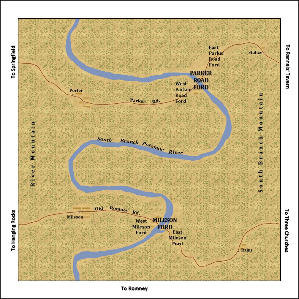
Federals hold the railroad from New Creek Depot all the way to Paw Paw Tunnel. The railroad is open to Okonoko, with repairs continuing towards Little Cacapon Depot and Paw Paw.  Federals also hold Taylor's Ford, Clasor's Ford, the Middle Fords (Mileson and Parker Road Fords), and Hanging Rocks.

The Confederates hold Points Cross Roads, Rannels' Tavern, Higginsville, Slanesville, Forks of Cacapon and Bloomery Gap as their northern line. They also hold Three Churches and Romney, including the covered bridge and Evans' Farm on the east side of the river at Romney. Confederates are in full possession of Glebe Ford and the farms immediately to its west. The Federals hold Purgittsville.

Lowell's Cross Roads, Spring Gap (inclusive if  Critton and Mooreland) and Tate are considered "no man's land" at the start of the campaign.

Tuesday, March 21, 2017

Burretsville

The TC2M Burretsville map has been uploaded on the mods page. It is an original map using a USGS topographic map for the area, now called Augusta, WV. Unlike most of the other maps in the campaign theatre, this map is free of rivers and mountains and has a lot of open space for artillery.

Burretsville links several maps. It lies between the Frenchburg and Pleasant Dale on the Northwest Turnpike and also joins the Bethel Church and Tear Coat Tavern maps to the southeast and southwest.


Confederates move east on the Northwest Turnpike, passing J. Danner. Burretsville in the background.

Engagement at D. Reed


Sunday, March 19, 2017

Tate's Store

BOW_Tate has been uploaded onto the TC2M Mods page. It is a simple, fictional map marking a junction of the Hampshire Morgan Turnpike and Sideling Hill Road. It is between Forks of Cacapon and Paw Paw Tunnel, and also has an exit to Spring Gap.


New and Revised Maps

I have posted a few new (and revised) maps on the TC2M Mods page. 

Little Cacapon Depot is not an accurate representation of the area. It is actually Great Cacapon, relabeled.

Points Cross Roads has been revised for TWWII and Okonoko has an added road leading to Little Cacapon Depot.

Rannels' Tavern is a fictional map, representing the cross roads of the Jersey Mountain and Parker Roads. It slides in between Three Churches and Points Cross Roads.

Hoy is a new junction that will be part of an expanded southwest section of the campaign map.

Spring Gap is the same, but the locality map has been re-labeled to show destinations on the roads exiting the map to the north.

Three Churches and Middle Fords have been re-labeled to show Rannels' Tavern.


Over-Ambitious

I was targeting June 1 for the next sim. I have realized that the expanded campaign theatre was just too large to complete by then. I am scaling it back down.

Sunday, March 12, 2017

Great Cacapon Depot

The map for Great Cacapon Depot is just about finished and I have sent it to Greg for a test run. It includes the B&O Railroad, the Great Cacapon River, Potomac River, C&O Canal, Great Cacapon Depot, Great Cacapon Bridge, and the town of Great Cacapon. I will make another version with the bridge and some of the rail destroyed, which will be the status at the start of the next simulation.